Newcastle City Council
Tree preservation zone
There is a problem
- 1000 entries with tree-preservation-order field must match the reference field in the tree preservation order dataset
Land to the rear of Pendower Way
- reference
- 2012/005.G3
- name
- Land to the rear of Pendower Way
- tree-preservation-order
- 2012/005
- tree-preservation-zone-type
- group
- geometry
- MULTIPOLYGON (((-1.669244 54.975171,-1.669256 54.975163,-1.669267 54.975150,-1.669265 54.975138,-1.669181 54.975075,-1.669038 54.974962,-1.669016 54.974937,-1.669020 54.974918,-1.669027 54.974897,-1.669026 54.974880,-1.669017 54.974874,-1.669005 54.974869,-1.668970 54.974866,-1.668926 54.974867,-1.668878 54.974873,-1.668863 54.974879,-1.668856 54.974886,-1.668849 54.974901,-1.668815 54.974929,-1.668793 54.974942,-1.668761 54.974958,-1.668730 54.974977,-1.668705 54.974989,-1.668688 54.975000,-1.668682 54.975024,-1.668684 54.975033,-1.668677 54.975042,-1.668546 54.975099,-1.668545 54.975104,-1.668593 54.975219,-1.668618 54.975244,-1.668686 54.975286,-1.668745 54.975329,-1.668796 54.975363,-1.668817 54.975380,-1.668843 54.975397,-1.668910 54.975449,-1.668945 54.975483,-1.668988 54.975515,-1.669017 54.975532,-1.669052 54.975549,-1.669085 54.975560,-1.669108 54.975561,-1.669129 54.975559,-1.669154 54.975553,-1.669166 54.975544,-1.669159 54.975534,-1.669143 54.975518,-1.669049 54.975438,-1.669010 54.975411,-1.668967 54.975384,-1.668915 54.975347,-1.668862 54.975303,-1.668799 54.975258,-1.668695 54.975192,-1.668649 54.975160,-1.668635 54.975144,-1.668629 54.975128,-1.668625 54.975111,-1.668626 54.975093,-1.668634 54.975080,-1.668648 54.975069,-1.668732 54.975026,-1.668896 54.974955,-1.668916 54.974954,-1.668979 54.975002,-1.669110 54.975120,-1.669172 54.975171,-1.669198 54.975181,-1.669221 54.975180,-1.669244 54.975171)))
- point
- POINT (-1.668906 54.97519)
- notes
- These data are update live via a feed to NCC's Tree Managament System, EzyTreev
- entry-date
- 2022-07-01
- start-date
- 2012-07-30
- end-date
How to fix this issue
Your data is missing a tree-preservation-order.
The tree preservation zone guidance explains how to fix the issue:
tree-preservation-order
The reference for the tree preservation order that covers this zone.
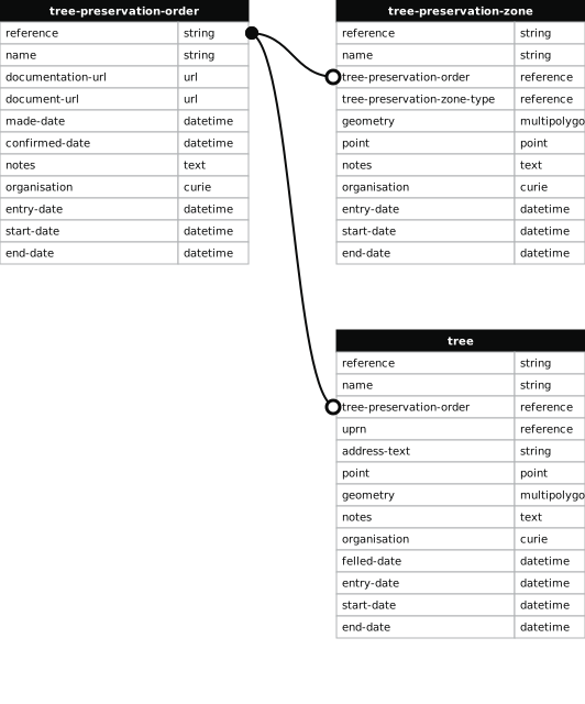
How to improve Newcastle City Council’s data
- Fix the errors indicated
- Use the check service to make sure the data meets the standard
- Publish the updated data on the endpoint URL